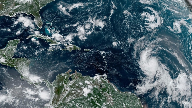
Hurricane Lee, a Category 3 storm, generated significant swells that battered the northeast Caribbean on Saturday. The hurricane, currently not projected to make landfall, is situated approximately 310 miles (505 kilometers) northeast of the northern Leeward Islands, boasting winds of up to 115 mph (185 kph) while moving west-northwest at 10 mph (17 kph).
Earlier this week, Lee remarkably escalated from a Category 1 storm to a Category 5 hurricane within a single day, fueled by warm waters and limited wind shear. AccuWeather described this rapid strengthening as “one of the fastest rates of strengthening in the Atlantic Basin on record.”
Lee is anticipated to undergo further intensification on Sunday and Monday, as predicted by the National Hurricane Center. Fortunately, the storm’s trajectory is expected to pass well north of the northeast Caribbean, providing relief to regions still recovering from the devastating impacts of hurricanes Irma and Maria in September 2017, including the British Virgin Islands and Puerto Rico.
While tropical storm conditions are not anticipated for any Caribbean island, Puerto Rico and nearby territories are expected to experience breaking waves of up to 15 feet (5 meters). Authorities have issued warnings urging people to avoid venturing into the water.
Captain Jose Diaz of the Coast Guard sector in San Juan, Puerto Rico, expressed concern, stating, “We are concerned about people and boaters who may underestimate the impacts of this passing storm.” He emphasized that the increased sea states of 10 to 15 feet severely limit the ability to respond to maritime distress situations.
The National Hurricane Center reported that seas near the hurricane’s center are forecasted to peak at 45 feet (14 meters). Additionally, the center highlighted the likelihood of dangerous surf and rip currents along most of the U.S. East Coast starting Sunday, although the hurricane’s impact beyond that remains uncertain.
AccuWeather meteorologist Bernie Rayno emphasized the need for vigilance in specific U.S. regions, stating, “Right now, the area in the United States that really needs to pay attention includes locations from the upper part of the mid-Atlantic coast to New England.”
Lee marks the 12th named storm of the Atlantic hurricane season, which spans from June 1 to November 30 and typically peaks in September. Additionally, Tropical Storm Margot emerged as the 13th named storm after forming on Thursday evening. Margot, located approximately 1,020 miles (1,645 kilometers) west-northwest of the Cabo Verde Islands, currently boasts winds of up to 45 mph (75 kph) and is expected to strengthen into a hurricane early next week. It is projected to remain over open waters.
The National Oceanic and Atmospheric Administration (NOAA) had previously forecasted between 14 and 21 named storms for this season. Within this range, NOAA expects six to eleven of them to become hurricanes, with two to five potentially developing into major hurricanes.
In the Pacific, Hurricane Jova remained far from Mexico’s southwest coast, posing no threat to land. It is located approximately 1,030 miles (1,655 kilometers) west of the southern tip of Baja California, moving northwest at 9 mph (15 kph) with winds reaching up to 50 mph (85 kph).


